Datasets
A dataset is a flight's images converted to temperatures with dji-thermal-cli's settings, with its mosaics. They are on the flight page's Datasets tab, where the page opens once there is one.
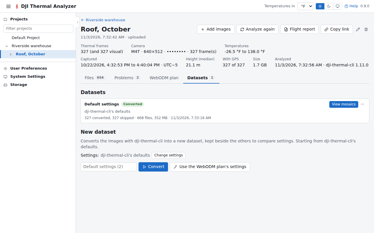
Converting
The tab lists the flight's datasets first, then the New dataset bar: the settings summed up and the Convert button. Change settings shows them all, each output named for what it is for, with dji-thermal-cli's name beside it. A problem a setting fixes opens this form with that setting already changed.
A dataset left unnamed is named after the settings that change its temperatures or mosaics ("Emissivity 0.9 · normalized", else "Default settings"), as the name field shows before converting.
You can keep several datasets side by side, cancel one while it converts, or download it.
The outputs
- Temperatures as TIFFs, which WebODM can process.
- The mosaics, opened in the viewer.
- The visual mosaic: when a flight has visual images, a dataset builds their mosaic with the thermal ones ("And the visual mosaic", on by default), at the visual camera's own resolution. dji-thermal-cli places each visual image where its thermal frame is in the thermal mosaic, after measuring and correcting the small angle between the two cameras, so the two mosaics line up. Zoom camera images are left out. It is in the downloads beside the thermal mosaics.
- R-JPEG (
rjpeg) writes each frame again as an R-JPEG with the dataset's measurement parameters in DJI's header, so DJI's own tools measure it as this app does. Its picture, what photo viewers show, is coloured with the dataset's palette or kept as DJI's.
A flight of visual images only
A flight with visual images and no thermal ones has nothing to convert: each of its datasets is the mosaic of its visual images, which dji-thermal-cli lays out by their own overlaps (matching them to each other, estimating the camera's lens distortion and the surface's heights), at the camera's full resolution. On the 327-photo test flight it took about 7 minutes. The New dataset form says so, its button is Make mosaic, and Change settings shows only what applies:
- Only frames with a gimbal pitch at or below (°): -80 keeps the nadir frames only.
- Pixel size (cm): empty for the frames' own.
- Height cells (px): empty for 32, in the pixels the frames are aligned at. Smaller cells follow steps in the surface, such as a roof's edge, more closely, and take longer.
- Remove the location from the files.
An unnamed one is named "Visual mosaic", followed by whichever of these settings are changed. Its card says Ready and View mosaic, and its files are the mosaic, its sidecar and its preview. It has no temperatures:
- In the viewer, a spot opens the frames that saw it, and a line or an area is measured for its length, or its area and perimeter, saved as a measurement or kept as a finding.
- Its frames are the flight's photos, shown as they were taken.
- On the compare page it can be shown beside any mosaic, or over one.
- Its mosaic report shows the mosaic with its measurements and findings.
It has no WebODM processing, and the flight's WebODM plan tab says there is nothing to plan.
Importing from WebODM
Import from WebODM, beside Convert, brings an orthophoto made in WebODM into the flight as a dataset of its own. Nothing is converted: the dataset is the orthophoto (and its surface model).
- From WebODM browses the projects of the app's WebODM account, newest first, with a search. A project's completed tasks with an orthophoto are cards, each with a preview of the orthophoto, its name, when it was made, and Orthophoto and DSM chips; those whose orthophoto lies over the flight's photos are marked Over this flight and come first. The project says how many tasks it has besides (still running, failed, or without an orthophoto). The chosen task is shown larger beside them, with its project, date, number of images and how long WebODM took, and Its DSM too when it has one (ticked at first).
- From a file takes the orthophoto's GeoTIFF from a task's Download assets on WebODM's page, and its DSM if
you have it (up to 1 GB each). The task's cameras, its Camera Shots (
shots.geojson) and Camera Parameters (cameras.json) from the same menu, are optional, both or neither: they find the flight's photos that saw a spot.
The dataset is named after the task or the file unless named in the dialog. Its card follows the download and the reading (Importing, with Cancel), then says Imported, where it came from and what it holds:
- Temperatures: an orthophoto of one band of values, read as °C as ODM writes them and shown in your unit, is the viewer's WebODM tab, as a task's orthophoto brought back is. Its preview is coloured with your palette.
- Colours: an orthophoto of red, green and blue is the dataset's visual mosaic, as a flight of visual images only has.
- DSM: its surface model, the viewer's Heights tab.
An orthophoto of anything else (several bands of values, or none georeferenced) isn't imported, and its card says why. One imported from a task has Open in WebODM, the task in WebODM's dashboard. View mosaics opens it in the viewer. An imported dataset has no settings, frames page or WebODM tasks of its own: its menu has Download all, Rename and Delete. One imported from a task brings the task's cameras along, for the frames that saw a spot.
A dataset's card
Each dataset on the tab has a card with its settings and progress. Its button is View mosaics once the mosaics are built (else Frames, or Cancel while it converts), and its menu (More) has:
- Frames, the frames explorer, and Compare with…, the compare page.
- Download all, the dataset's files as a zip, made as it downloads.
- Files, its files listed on the card, each opening its frame.
- Use settings, its settings put back in the New dataset form.
- Build mosaics, when they were not built with it.
- Process in WebODM (see WebODM).
- Rename and Delete. Deleting a dataset deletes its measurements too, and a Delta T across it and another dataset from that one as well.